Overview of the Resource
The paper titled “City composition and accessibility statistics in and around Paris” is published in Frontiers in Big Data (2024) and authored by Thaury, Genet, Maurice, Tubaro, and Berkemer. It presents an empirical test of the “15‑minute city” concept, contrasting a highly accessible central area of Paris with its less‑equipped, lower‑income periphery. The study is publicly available through the National Center for Biotechnology Information (NCBI) portal (https://pmc.ncbi.nlm.nih.gov/articles/PMC10941645/).
Research Objectives and Methods
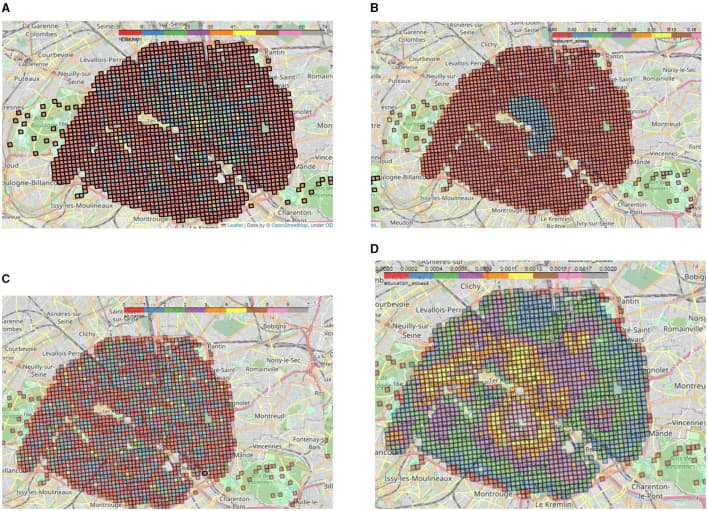
The authors aim to quantify spatial accessibility and residential composition across the Paris metropolitan region. Using big‑data analytics, they combine census data, transportation networks, and land‑use information to generate accessibility scores for each neighbourhood. The methodology includes GIS‑based travel‑time calculations, socioeconomic stratification, and statistical comparison between central and peripheral zones.
Key Findings on Accessibility
- Central Paris exhibits an average travel‑time of ≤15 minutes to essential services (schools, healthcare, shops) for over 85 % of residents.
- Peripheral districts show a travel‑time exceeding 30 minutes for more than 60 % of inhabitants, indicating limited access to daily needs.
- Accessibility gaps correlate strongly with income levels: lower‑income areas experience the longest travel times and the lowest service density.
Housing and Socio‑Economic Patterns
- The central area’s housing stock is predominantly high‑density apartments with median rents 30 % above the city average.
- Peripheral zones contain a higher share of low‑rise, older housing units, with median rents 15 % below the city average but with poorer energy performance.
- Population density declines from 21,000 inhabitants/km² in the core to 3,500 inhabitants/km² in the outer suburbs.
Implications for Sustainable Housing
The study highlights that sustainable urban living depends on equitable access to services and efficient public transport. In the central district, shorter travel distances reduce carbon emissions from private vehicles, supporting climate‑friendly mobility. Conversely, the peripheral areas’ reliance on longer commutes contributes to higher per‑capita emissions, underscoring the need for integrated housing policies that improve local service provision and promote energy‑efficient retrofits.
Policy Recommendations Derived from Data
- Expand public transport reach into underserved suburbs to lower average travel times below the 15‑minute threshold.
- Invest in energy‑saving upgrades for peripheral housing, targeting insulation and renewable heating to close the performance gap.
- Encourage mixed‑use development in peripheral zones to increase local availability of essential services.
- Implement affordable housing incentives in central areas to prevent socioeconomic segregation while maintaining high accessibility.
Data Availability and Transparency
All datasets used in the analysis are sourced from open government portals and are fully documented in the supplementary material of the article. The authors provide reproducible code scripts, facilitating further research by planners and scholars across Europe.
Relevance for a Pan‑European Audience
The Paris case offers a template for other European cities aiming to achieve the 15‑minute city model. By quantifying the disparity between central and peripheral zones, the paper supplies actionable metrics that can be adapted to diverse urban contexts, informing sustainable housing strategies, transport planning, and social equity initiatives throughout the continent.